



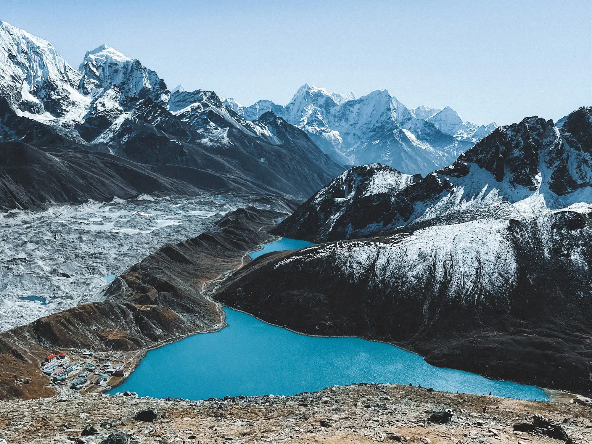
Nepal’s mountains offer views, landscapes and panoramas found almost nowhere else on earth. They are one of the main reasons people travel from around the world to Nepal.
But that beauty comes with a price.
The Himalayas are steep, geologically active and constantly changing. Landslides, avalanches, earthquakes, glacial lakes and sudden floods are part of this environment. For us as a tour operator, understanding those risks is just as important as knowing where to find the most beautiful places.
The devastating flood that struck the Nepal–Tibet border on 26 August 2026 is a painful example.
What happened?
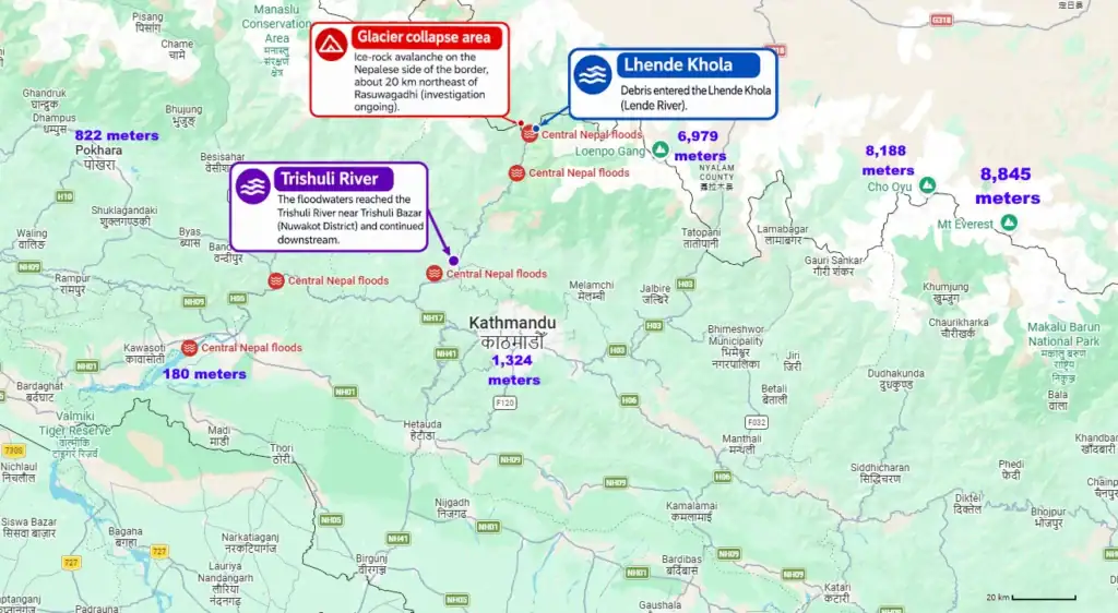
A huge section of glacier ice, together with rock and debris, collapsed high in the mountains close to the Nepal–Tibet border.
Professor Rijan Bhakta Kayastha, a glaciologist at Kathmandu University, told CNN that the glacier involved in the collapse is on the Nepalese side of the border. According to Kayastha, the ice avalanche blocked the Lhende River, which flows across the Nepal–Tibet border.
Water accumulated behind this temporary blockage until it gave way, sending a huge volume of water, ice, rock and debris downstream towards Rasuwagadhi.
The location caused some confusion in the first reports because the Lhende is a transboundary river and the flood was reported as coming from the direction of Tibet. That does not mean the glacier itself was in Tibet. Based on the assessment given by Professor Kayastha, the glacier that collapsed was on the Nepalese side.
There was another source of confusion.
Seismic instruments detected shaking equivalent to approximately a magnitude 5.2 earthquake, leading to early reports that an earthquake might have triggered the disaster. The US Geological Survey later clarified that there had been no earthquake. The seismic signal was generated by the enormous glacier collapse and debris flow itself.
Nor was this a typical monsoon flood caused by exceptionally heavy local rainfall. Nepal’s Department of Hydrology and Meteorology reported that there had been no heavy rainfall in Rasuwa on the day of the disaster or the previous day.
Scientists are still analysing the event, including satellite data and the exact sequence of the collapse, blockage and flood. We will update this article if new research or official information changes the current understanding of what happened.
Why were there hundreds of tourists in such a remote area?
The large number of international travellers reported in the area needs some explanation.
Rasuwagadhi is an important land crossing between Nepal and Tibet and, in particular, a gateway for pilgrims travelling to Mount Kailash and Lake Mansarovar.
On the morning of the disaster, nearly 400 Kailash-bound pilgrims were preparing to cross the border into Tibet. They were clients of several organised travel and trekking companies. The initial group included 93 Nepalis and almost 300 foreign visitors.
Mount Kailash and Lake Mansarovar are sacred destinations, particularly for Hindus, Buddhists, Jains and followers of Bon. Large organised groups travel through this border crossing during the pilgrimage season.
This is quite different from the way most Western leisure tourists travel through Nepal.
For travellers visiting Kathmandu, Pokhara, Chitwan, Everest, Annapurna and Nepal’s other major destinations, Rasuwagadhi is not part of the normal itinerary.
For international leisure travellers combining Nepal and Tibet, flying between Kathmandu and Tibet is a normal means of transportation used by travellers and tour companies. Most visitors to Nepal therefore have no reason to travel anywhere near this border crossing.
Could an early-warning system have helped?
The area affected on 26 August did not yet have an early-warning system.
Nepali Member of Parliament Dhananjay Regmi told CNN that the risk had been studied following a previous event in July 2025 and that an early-warning system was planned for this year, but had not yet been installed.
Regmi estimated that because the flood originated around 30–35 kilometres upstream, a functioning warning system might have provided approximately one hour to move people to safer ground.
At Imja Tsho in the Everest region, such protection already exists.
The water level of Imja Lake was lowered by approximately 3.4 metres in 2016. Hydrological and GLOF sensors were installed, together with automated warning sirens in six settlements along approximately 50 kilometres of the Imja–Dudh Koshi corridor.
According to UNDP, the system helps protect more than 90,000 people as well as thousands of visitors travelling through the region.
At Tsho Rolpa in the Rolwaling region, Nepal has also lowered the lake level and installed monitoring and early-warning infrastructure.
Automated climate monitoring and early-warning systems are also operating across seven watersheds in Nepal, including high-altitude watersheds. The systems use equipment including automatic weather stations, river and flood sensors, real-time monitoring and community warning systems.
What about Nepal’s other glacial lakes?
ICIMOD and UNDP identified 47 potentially dangerous glacial lakes in the Koshi, Gandaki and Karnali river basins.
Of these:
- 21 are in Nepal
- 25 are in Tibet
- 1 is in India
Forty-two of the 47 are in the Koshi basin. Thirty-one are classified in the highest of the three risk categories used in the study.
These figures refer specifically to potentially dangerous glacial lakes. The 26 August disaster is a reminder that Himalayan hazards are not limited to the failure of known glacial lakes: large collapses of glacier ice, rock and debris can create a different type of sudden flood.
More protection is being installed
Nepal is investing significantly in expanding its monitoring and protection.
A seven-year programme supported by a US$36.1 million Green Climate Fund grant is expanding and upgrading hazard monitoring and early-warning systems.
Four high-risk lakes are being targeted for water-level reduction:
Thulagi, Lower Barun, Lumding Tsho and Hongu 2.
The programme also includes strengthening vulnerable riverbanks, improving emergency preparedness and expanding monitoring. UNDP says around 2.2 million people will benefit from the project.
Safety when travelling in Nepal
A natural disaster in one Himalayan valley does not mean Nepal as a whole has suddenly become unsafe.
Nepal stretches from the lowlands of the Terai to some of the highest mountains on earth. Kathmandu, Pokhara, Chitwan, Annapurna, Everest and other tourism areas are separated by large distances and very different geography.
For us at Amazing Kathmandu Tours, safety starts before a guest gets into a vehicle or puts on their walking boots.
We know where established early-warning systems are operating. We follow information from Nepal’s authorities and hydrological and weather services, and we use our local network to check conditions when planning and operating trips.
We assess the specific route and destination rather than making decisions based on conditions somewhere else in the country.
If we consider a route unsafe, we don’t take our guests there.
We can change a route, postpone part of an itinerary or choose another destination. Nepal offers enough alternatives that there is no reason to take an unnecessary risk simply to stick to the original plan.
The spectacular landscape is why people come to Nepal. Understanding that landscape is part of our job.
Main photo: Marina Zvada
Sources and more info
CNN – Interview with Prof. Rijan Bhakta Kayastha, Kathmandu University
One of the clearest expert explanations of the event. Kayastha discusses the location of the glacier collapse on the Nepalese side of the border and how the ice, rock and debris affected the Lhende River system.
CNN interview with Prof. Rijan Bhakta Kayastha
CNN – Interview with Dhananjay Regmi, former CEO of the Nepal Tourism Board
Discussion of the satellite evidence and early assessments of what happened, including why the event was initially confused with an earthquake.
CNN interview with Dhananjay Regmi
CNN – Interview with Qiangong Zhang, ICIMOD
Scientific analysis from the International Centre for Integrated Mountain Development. Zhang discusses evidence that an ice-and-rock avalanche originating from glaciers on the Nepalese side reached the border river.
CNN interview with Qiangong Zhang
CNN – Interview with Rishi Khanal, Nepal Red Cross Society
Information about the impact of the disaster, destruction in the affected area and the emergency response in Nepal.
CNN interview with Rishi Khanal
ICIMOD – International Centre for Integrated Mountain Development
The leading regional scientific organisation studying glaciers, climate and mountain hazards across the Hindu Kush Himalaya, with experts involved in analysing this event.
ICIMOD official website
Kathmandu University
Academic institution of Prof. Rijan Bhakta Kayastha, one of the Nepalese glacier experts interviewed by CNN about the collapse and its likely causes.
Kathmandu University official website
Nepal Red Cross Society
Official humanitarian organisation involved in emergency response and assistance following disasters in Nepal.
Nepal Red Cross Society official website
CNN – What we know and don’t know about what caused the Nepal flood wave
A detailed overview bringing together satellite observations and expert analysis, including comments from Daniel Shugar of the University of Calgary and Saswata Sanyal of ICIMOD about the collapse and the seismic signal it generated.
Read the CNN report
Reuters – What triggered the catastrophic flood on the Nepal-Tibet border?
Independent reporting examining the evidence for the glacier collapse, the resulting flood and scientists’ assessment of what triggered the disaster.
Read the Reuters report
US Geological Survey (USGS) – Seismic monitoring
The USGS monitors and analyses earthquakes and other seismic events worldwide. Its seismic data was important in establishing that the shaking detected during the 26 August 2026 disaster was associated with the enormous glacier collapse and debris movement rather than a conventional earthquake.
US Geological Survey – Earthquake Hazards Program
Nepal’s Department of Hydrology and Meteorology (DHM)
Nepal’s national authority for hydrological, meteorological and cryosphere data. DHM operates monitoring, forecasting and early-warning systems used to assess floods and other water-related hazards across Nepal.
Department of Hydrology and Meteorology – Government of Nepal
UNDP – Glacial flood risk reduction in Nepal
UNDP works with the Government of Nepal on reducing the risks from glacial lake outburst floods and climate-induced flooding. Its work includes glacier and river monitoring, early-warning systems and measures designed to protect vulnerable downstream communities.
UNDP – Protecting livelihoods and assets from glacial floods in Nepal
Green Climate Fund – $36.1 million grant for glacial flood protection in Nepal
The Green Climate Fund approved a $36.1 million grant for Nepal to reduce risks from glacial lake outburst floods and climate-induced flooding. The seven-year FP272 project is implemented with UNDP and includes improved monitoring, early-warning systems and measures to protect vulnerable communities. The project became operational in March 2026.
Green Climate Fund – FP272: Glacial flood risk reduction in Nepal
UNDP – Green Climate Fund approves $36.1 million for Nepal
UNDP’s announcement explaining the GCF-funded programme, including its partnership with Nepal’s Department of Hydrology and Meteorology and the measures being taken to reduce future glacial flood risks.
UNDP – Green Climate Fund approves $36.1 million for Nepal


2 thoughts on “The Beauty of Nepal’s Himalayas Comes With a Price”